Check-Ins
| When? | Who? | Comment | Place | Location |
|---|---|---|---|---|
|
TheAtlasEndurance
|
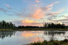
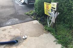
Well established campground with room for rvs, campers, and tents. Picnic table, fire ring, water and electrical hook ups at most sites. Bathrooms with showers available. There was a ranger on site that met us at our site when we arrived. Made reservation over the phone same day since their website required the reservation to be made at least 2 days in advance. Overall, good place to camp - only caution is to beware of the mosquitoes! |
village Creek state park | 35.16372, -90.70992 | |
|
jakelleyrn
|
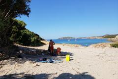
Great place! Multiple pull offs along the road for vehicles who can’t make it on sand. You will need a vehicle able to handle sand. We had a Jeep Gladiator with a RTT and still got stuck on the way back out. Aired down, dug out and had some friendly guys push us back onto harder sand. Then took a different route out with no issue. Beautiful camping o the beach and pretty chill. Beach is long and you can camp wherever, just make sure you’re above high tide. There are some areas before the beach for camping as well. We went Labor Day so it was busy but my gf said she never felt safer than this spot. We went far down the beach and couldn’t see another vehicle until everyone’s toys came out in the AM. |
Siuslaw National forest - by the beach | 40.90986, -124.08969 | |
|
adele.bordoni
|
2 km of gravel road not maintained. Only transitable by off road cars or cycles.
|
Cala de Sa Perda Longa | Location Missing! | |
|
||||
|
katiellykb
|
We are a natural hot water hotel. We have a restaurant, convenience and thermal pools. |
Thermas Hotel Marihá | -16.03721, -54.88499 | |
|
dpbryck
|
Free spot on residential side street up the hill from Walker Art Institute. Might be tough for larger rigs depending on how much space is available as street is on a bit of a curve. Pay attention to signage- no parking on either side of the spot. Bathrooms in Walker Art Institute are available when museum is closed. |
Groveland Terrace by Walker Art Center | 44.96842, -93.29079 | |
|
katiane_dc
|
É enorme e tinha bastante gente quando fomos. É daqueles lugares cheios de opção de atividade paga à parte pra fazer, estilo hotel fazenda mesmo. Não faz muito o nosso estilo, mas pra quem gosta é uma baita estrutura. |
Hotel Fazenda Evaristo | -26.30111, -49.53426 | |
|
sunnraayy
|
Road closed as of September 5th. Seemed like it could’ve been a nice spot close to the river. |
Court House Creek Road | 35.30124, -82.94050 | |
|
vsavatgy
|
Pullout with a fire ring, but literally right off the road. |
Creekside Campspot off Hwy 153 | 38.25542, -112.52757 | |
|
wittles33
|
Very cool bar and grill near camping Maxwell National Wildlife Refuge. Occasionally let’s people camp overnight. Great vibe, drinks and food. The nice Christian lady was great! |
Cold Beer New Mexico Tavern & Grill | 36.60659, -104.72515 | |
|
||||
|
bekwallalala
|
Amazing spot for camping outside of Moscow with gorgeous views |
McCroskey State Park | 47.05333, -116.88444 | |
|
bryanbequette
|
Downtown small RV parking, three 25 foot pads, with electric (110, 30, & 50), city water and Wi-Fi. Laundry mat, library, restaurants, and historic sites within just a few blocks. |
Nebraska City RV Park | 40.67497, -95.85486 | |
|
jillybean1952
|
Drinking fountain with lower spigot to refill jugs. Next to parking |
Rest Stop. East bound | 38.39205, -82.42200 | |
|
regulatorytrick52
|
posto de combustível. lugar tranquilo porém não funciona a noite. pátio aberto para estacionamento. |
Fuel station Pontal do mel | -4.95764, -36.88264 | |
|
hjrler
|
Baie mooi skoon met goeie geriewe. Aan te beveel vir oornag. |
Bundu River Camp | -28.22313, 27.07892 | |
|
bellcoglass
|
Well lit, was quite , trucks weren’t running all night, not much traffic, bathrooms were so so, felt safe. |
Eastbound Rest Area | 39.32797, -101.90253 | |
|
khaupt1993
|
Only spent a few hours here so can't tell a lot. beautiful though! |
Poole knobs campground | 36.05818, -86.51782 | |
|
||||
|
katjpat21
|
Stayed the night. Very quiet as of 9 pm. Fills up quickly. Great location. Went for dinner in one of the many great restaurants. Merci Saint Sauveur 😀 |
Saint Sauveur - Town Hall Parking | 45.89503, -74.15220 | |
|
||||
|
noble.frog8987
|
Gravel parking lot somewhat level many vehicles overnighting |
Vermont Distiller | 42.85370, -72.79579 | |
|
smnblgt1
|
Very nice, clean place. Semi’s use the front parking area; vehicles/rv’s in back closer to the small, lily pad filled lake. Toilets, picnic tables available.
|
Lodge Lake Park (before was:Highway 17 Rest Stop with Beautiful Lake | 49.25272, -91.11311 | |
|
||||
|
damien.dykman
|
Eastern pull out still good for overnight but west side has a no camping sign |
Cameron Road | 39.18414, -123.73761 | |
|
damien.dykman
|
Still good for van camping on the West side pull out but no camping sign on the East side pull out |
Cameron Road | 39.18427, -123.73746 | |
|
dshiinaay
|
Very nice to sleep , and stay how many days u want no problems no plates |
Street parking | 33.85321, -118.39295 | |
|
camilleburns.99
|
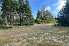
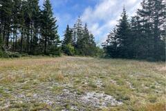
long bumpy road but very quiet place. Felt isolated. Big space. Photos attached |
Keppoch Mountain | 45.51729, -62.12510 | |
|
||||
|
drichter6
|
Lovely site just off the Trans Canada highway, stayed overnight. Clean, large garbage bins. Looked in the pit toilets but didn’t use, no toilet paper, but did have hand sanitizer.
|
Broadview Recreational Area | 50.37925, -102.62577 | |
|
||||
|
mikemercury12000
|
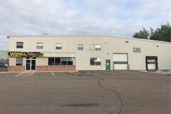
Nice dump station
|
Work and Play Limited | 46.07515, -64.82336 | |
|
||||
|
suncitysteve
|
This place is permanently closed. |
Willows Rest Area | 39.59199, -122.21001 | |
|
kkopplien
|
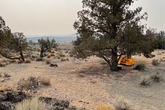
Took a left at the Badlands Wilderness sign and drove about 1/4 mile down the paved road. Spots are at the first sand road on the right. No, ‘no camping signs’ Several awesome wide open spots with great views and fire pits. Rock formations and lots of juniper trees. A bit exposed to the wind, had a hard time sleeping in tent due to wind noise. Overall, a great, secluded and peaceful spot to camp. Will visit again. |
Dry River Canyon Bluff - BLM | 43.95141, -121.02086 | |
|
||||
|
paddingtonbear
|
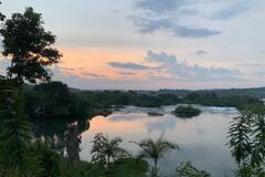
Wow what a place. This place is seriously underrated on here. Our favourite campsite in Africa, the food was incredible and views over the rapids were insane. David, the manager is the best! He will sort you out with a good deal if you tell him you’re an overlander. Showers and toilets are excellent. Couldn’t recommend enough. |
The Haven | 0.54272, 33.08978 | |
|
||||
|
Direction East
|
Lovely place, very quiet, great breakfast, super nice owners. Gated parking for motorbikes available, car maybe upon request.
|
MagHay B&B | 40.80498, 44.49274 | |
|
anniehavis
|
Amazing spot. 6 other campers parked when we arrived. Huge dog park, soccer field, splash pad and park for kids. Lots of picnic tables and toilets. Beautiful relaxing site on the Richelieu river. |
Centre De Plein Air Ronald-Beauregard | 45.28884, -73.25252 | |