River Crossing - Rio Ario | Warning
Costa Rica
Details
- Verified:
- about 2 months ago
- GPS:
- 9.72434, -85.19317
- Altitude:
- 13.0 masl
- Contributor:
-
 travelingtogether814

Amenities
Something not right?
Description
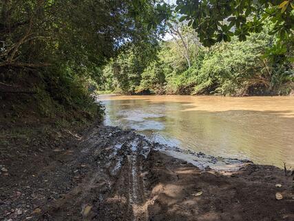
When traveling from North to South drive straight into the river and go downstream approximately 60 m toward the private road. Begin to turn your vehicle to the left while in the current until you are driving up stream along the Southern river bank. Proceed up the river for approximately 70 m to marked exit on the right.
Why? By checking in after you’ve visited a place you let others know this place is still functional. You can also add or correct any information.
Latest Check-Ins
Easy just stay in the curve - knee high solid rocky bed
There are arrows to show the direction
Crossed from North to South in 2007 Toyota Fortuner with water approximately wheel depth. Drive straight into the river downstream for approximately 60 m toward the private road. Begin to turn your vehicle to the left while mid-current until you are facing up stream and are along the far bank. Then drive up the current approximately 70 m to marked exit road on the right.
Report Check-Inlow river, you can cross it all year round, sometimes if there is too much rain it can be closed for a few hours .
Report Check-InAt this time the water level was about 30cm. Going to montezuma, drive up the river bed on the left to take the other road.
Report Check-InOnly 6” of water at this time. Coming from north as mentioned don’t forget to make a left. If you go straight you’ll end up on a private road to nowhere like I did.
Report Check-InWe had no problems with this at the start of Feb. We were heading south and stuck to the right hand side just to be sure but everything was fine.
Report Check-InFun river crossing, water is 40cm deep and easily doable with 4x4. Make the turn to the left if you come from the north otherwise you will end up a wrong road.
Report Check-InPassed easily as the water is clear...about 30cm deep.
Coming from the North, cross straight over and then take a left along the river through the water to reach the other road.
River was about 60- 75 cm high, but you need to go 50 m up stream and the cuarrend was strong , but ok for us with 4×4 and snorkel. it was a god day saw the water marks wich were about 60 cm higher means up to 1,20 m all in all so could be im posible after hard rain
Report Check-InNo problem in our loaded down 2wd Vanagon with all terrain tires. The river was just under knee deep. It is the end of the dry season not sure about later in the year.
Report Check-InFuimos de Montezuma a Playa del Coco, bordeando la costa, y todos los rios estan secos, cualquier carro los puede cruzar sin problema durante la temporada seca (con lluvias es mucho mas complicado!). Igual la carretera no es asfalto!
Report Check-InStoney underground. 40 cm deep. You need to take the crossing 50 m upstream. You can see the underground while you cross
Report Check-In