Cedar Creek Falls Trailhead | Wild Camping
United States
Details
- Verified:
- almost 2 years ago
- GPS:
- 43.96434, -113.58004
- Altitude:
- 1806.2 masl
- Website:
- None
- Contributor:
-
 lambsundries

Amenities
- Electricity:
- No
- Wifi:
- No
- Kitchen:
- No
- Restaurant:
- No
- Showers:
- No
- Water:
- Natural Source
- Toilets:
- No
- Big Rig Friendly:
- No
- Tent Friendly:
- Yes
- Pet Friendly:
- Yes
Something not right?
Description
iOverlander cannot verify if wild camping is permitted at this location. It is your responsibility to verify local laws or obtain consent before staying the night.
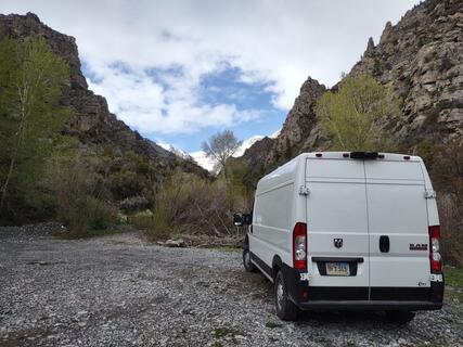
National Forest Trailhead. Picnic table and fire ring. Room for three vehicles at trailhead. The rough road leading to the trailhead is in BLM land. And there are plenty of places to pull off along the road. Follow signs for Cedar Creek, do not follow Google maps after leaving Mackay. Go past land fill, past a sign at a small road pointing further south to the Cedar Creek road entrance sign. Road is rocky, so go slow. There is a dry creek crossing that looks more formidable than it is about half way to the trailhead.

Why? By checking in after you’ve visited a place you let others know this place is still functional. You can also add or correct any information.
Latest Check-Ins
National Forest Trailhead. Picnic table and fire ring. Room for three vehicles at trailhead. The rough road leading to the trailhead is in BLM land. And there are plenty of places to pull off along the road. Follow signs for Cedar Creek, do not follow Google maps after leaving Mackay. Go past land fill, past a sign at a small road pointing further south to the Cedar Creek road entrance sign. Road is rocky, so go slow. There is a dry creek crossing that looks more formidable than it is about half way to the trailhead.
Report Check-In