EX Ruta 40 | Warning
Argentina
WARNING: THIS PLACE HAS BEEN FLAGGED FOR DELETION!
Details
- Verified:
- 5 months ago
- GPS:
- -48.40525, -70.51603
- Altitude:
- 479.3 masl
- Contributor:
-
 austronauts.wordpress.com

Amenities
Something not right?
Description
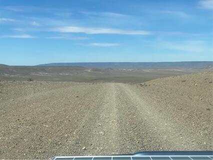
*The 29 road that google maps shows you here is unpaved. The 29 reunites with Ruta 40 south of this icon where the southbound Ruta 40 is also unpaved (see the warning icon labeled “northern start of gravel road”). The Ruta 40 section between this warning label and the one below is presumably paved.
On december 2023 : The 29 is an unpaved gravel road in a rather good condition : no washboard, but some loose gravel sections. Any kind of vehicule can do it, but your average speed can greatly vary according to the vehicule type and the driver.
Why? By checking in after you’ve visited a place you let others know this place is still functional. You can also add or correct any information.
Latest Check-Ins
We took the 29 road from north to south to avoid Gobernador Gregores. It's a unpaved gravel road. The condition of the road is OK, no washboard, but some parts are a little worse with more loose gravel than others (but road condition can quickly change). It's doable with any kind of vehicule without difficulty, but how fast you can go depend on the type of your vehicule (with a 4x4 Nissan Xtrail we drove between 50km and 70km/h). Very few other cars. We dont regret taking this shortcut even if we cant compare with the other one.
Report Check-InWe drove Ruta 40 all the way North to South, but hopped on the 29 to avoid Gobernador Gregores. The 29 is gravel and has a few bumpy sections, but overall I’d say it’s a “good” gravel road. Between this warning icon and the next one below, the 29 takes about an hour to drive vs. Ruta 40 that takes 2 1/2 hrs and drives through Gobernador Gregores. We’re cautious gravel road drivers and were comfortable driving 70-90km/hr in our ‘99 Chevy Express for majority of the 29 and the unpaved section of the 40. Happy travels!
Report Check-InIf you want to avoid going all the way to Gobernador Gregores, take route 29 down (shortcut). It's a non-paved road, we had no problem driving it on a sunny day. :)
Report Check-InSince I found most of the entries given here very confusing (and some are really bad - like „did it in 1h, was nice“ - not all travelers do own a super fancy car with bulletproof tires and have massive experience with gravel roads, this does not help at all!), and since we drove both rutas, RN40 via Gobernador Gregores and RN288, I just wanted to write down our experiences:
If directly traveling from north to south or vice versa, you HAVE to drive on a gravel road. There is no way to avoid this (except, maybe, by driving eastbound and going down along the coast, but not sure about this). The unpaved part of RN40 (make sure your route leads through Gobernador Gregores) is about 75 km long, RN288 has about 130 km of unpaved road. Both roads have sections that are pretty good to drive on, but also lots of sections with very big rocks and earth on the road. RN40 has more sections covered with earth than RN288. Also, the northern part of RN40 is mostly ok whereas the southern part is hardier. RN288 is pretty much the same all the time. This is why we would recommend driving RN40 if the weather is good, and if there is light rain RN288 is better with 2WD. With enough experience and a good 4WD car, you can do both in the rain if they are open. In any case, check with a nearby police station what they recommend. Conditions can change at any time, it’s Patagonia. Otherwise, as already stated by others: Just make sure to deflate your tires, and drive slowly if you feel uncomfortable. No need to rush.
We did not drive the „old“ Ruta 40, which avoids Gobernador Gregores. No idea about this road part.
Report Check-InGoggle maps still routes you through the old Ruta 40. Its your average patagonian ripio road. Relatively smooth, very few washboards. Comparable or better than the unpaved Carretera Austral.
Report Check-InThe road to Gobernador Gregores coming from north is all paved! And except from a very few potholes in good condition.
The road to the city is now the ruta 40.
Report Check-InWould definitely recommend to follow google maps and NOT avoid Ruta 40 if you’re headed towards Chalten from here. The unpaved part is only 70km and some of the best gravel roads we’ve ever driven.
Report Check-InGoogle maps wants to send you on the old Ruta 40 to the south. You have to go through Gobernador Gregores on the 25 and 29 if you want to stay on paved roads. The road google maps shows you is the old route and unpaved!
Google maps mostra la EX Ruta 40. Hay que manegar via Gobernador Gregores en la ruta 25 y 29 si se quiere quedarse en asphalto. Google maps mostra la ruta vieja sin asphalto!
Report Check-In