Check-Ins
| When? | Who? | Comment | Place | Location |
|---|---|---|---|---|
|
busleven
|
Great fill up point. You can park right next to the fuel station type hose and fill up. Very high pressure. |
water fill up point | 19.64296, 41.90925 | |
|
2gether 2 end.ofthe.earth
|
SA to Lethoso, only fee was 75 Rand for car entry at the border toll booth. coming back no fees for SA car entering SA. leaving Lethoso they handle the passports at the window while your in your car. |
Caledonspoort Border Post | -28.69415, 28.23408 | |
|
hihosilver.van
|
Spent one quiet night. The detour around the damaged road was easy to find with the help of the locals and we were able to make it with our 3.2 meter tall rig with only a few mild brushes of tree branches. Pretty and mostly level spot and very popular with the locals. We arrived at sunset and there were folks swimming and enjoying an evening walk. Very quiet after dark, except for one short fight between the resident beach dogs in the middle of the night. Quite warm and humid after spending a week in Oaxaca city! Also, lots of trash, so do your part and keep it clean and consider packing a bag of trash up on your way out |
Benito Juarez Lake | 16.46188, -95.43839 | |
|
pseidner81
|
As stated below gorgeous spot! Will definitely come back. Online Reservation required. I just really wanted to add you will need to go through Westgate River Ranch Resort and Rodeo. I thought I was in the wrong place but the nice lady at the guard house told me I was heading the right way. Just let them know you are camping at Kicco and they will let you in. Turn right just past the TP’s and keep on driving down the dirt road. You will come to a gate at the trailhead which requires a gate code to enter. This will be emailed to you when you make your reservation. Then drive another 8 miles through some picturesque countryside to the campsite. No facilities so please pack in and pack out! Let’s try to keep this place available to enjoy for years to come! |
Town of Kicco campground South Florida WMA | 27.66901, -81.14413 | |
|
Chris
|
Great selection of farm basics and local products. |
Farm Shop | -0.82038, 36.26308 | |
|
haugen.gabriel
|
No issues staying here in truck/travel trailer 2 nights. Several other rv’s |
Walmart-Largo | 27.91452, -82.72764 | |
|
gmail.com
|
PJM Response. Ambulance and remote rescue services including air evacuation and Kariba lake recovery |
Pjm Response Ambulance | -17.78362, 31.11964 | |
|
TETravels
|
The absolute best food lovers market we've ever been to. It's a luxury supermarket but with very reasonably priced fruit veg and meat, but also all the imported ingredients we haven't seen anywhere else since SA! Delicious cheeses, cold meats, speciality frozen products, imported Italian and Mexican food etc. Absolute delight |
Food Lovers Market | -13.90684, 33.79018 | |
|
lacoloinquieta
|
Excelente lugar para pernoctar. Tiene todo lo necesario. Juscelino es muy amable. |
Posto Vitoria | -12.13957, -38.39282 | |
|
||||
|
La_Fordtuga
|
Fine place to stay if it’s getting dark and you need somewhere to stay. It’s on a steep section of hill, so the traffic was extra noisy. They have a bunch of sweet [if loud] dogs. Washrooms we’re private and clean. The couple that hosts is very sweet. Contact number is (315) 637-2853. 30k for 2 people. |
El Argentino restorente | 7.04197, -73.08988 | |
|
peggyann.boucher
|
Très tranquille, il y a un endroit au niveau assez large qui n'est pas en face de maisons. Très pratique pour stationner le vr pendant votre visite aux piscines salées et pour la nuit. Nous avons cuisiné dehors aussi. Personne la nuit car les piscines ferment à 18h. Toilettes et douches froides disponibles avant 18h.
Very quiet, there is a place on a fairly wide level that is not in front of houses. Very convenient to park the rv during your visit to the salt pools and for the night. We cooked outside too. Nobody at night since the pools closes at 6pm. Toilets, cold shower available before 6pm.
|
Safe and quiet street parking close to the pools | 13.49620, -89.42012 | |
|
||||
|
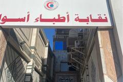
cyriletvane
|
offices on the 2nd floor to the left of the supermarket, where you can request your authorization to go to abu simbel with your own vehicle. there are a few people who speak English. you need your passport, international permit, CPD and vehicle license card. In a few minutes, it was settled: we still got help from a local who was introduced to us by the tourist police of the town, for a few pounds. |
Egyptian travel agents association Aswan branch | 24.11325, 32.89975 | |
|
||||
|
ourtraveldiscoveries
|
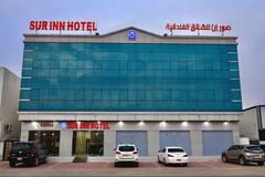
Adding this wonderful place because 1) the apartments are lovely and fully equipped at European standards; 2) the staff is super friendly; and 3) they have a WASHING MACHINE in the apartment! We have only found expensive laundry services in Oman and little to no hotels where we could do laundry, so if you have many loads to wash, this is a great place to do it! We paid 40$ per night. Fast WiFi, private secure parking in front of the hotel, supermarkets and restaurants nearby. You can WhatsApp/call them ahead of time to book and arrange the washing machine in the apartment at +968 7999 0349 |
Sur Inn Hotel Apartments | 22.56165, 59.47495 | |
|
||||
|
3weltreisen.de
|
it is a parking lot for the Restaurant, the area is beautiful, the lot not Level, but quite, 3 big rigs or 5 Vans will fit, road is paved, not the last 100m, you will eat in the Restaurant, menue is small but great, prices are fine, only spanish |
RV Park Eco Tours | 27.42976, -112.52620 | |
|
||||
|
mmq-photography.com
|
Café/ restaurant with open WiFi. Open from 11am. Perfect for early birds after having seen the glacier from the boardwalks. |
resto de glaciar | -50.46216, -73.02520 | |
|
haugen.gabriel
|
Friendly staff, still only $5 to dump and fill freshwater |
Encore Vacation Village | 27.89147, -82.73326 | |
|
nenitosviajeros
|
toilets, shower (cold). safe and nice night |
gas station maría beatriz | -0.94340, -79.24213 | |
|
erika_g
|
We went to the garage next to the shop.
|
Repuestos Lubricantes | -43.18620, -71.86807 | |
|
anke.verburg
|
Great place, free hot showers, dog friendly, stayed two nights. T-Mobile 3bars, good Internet. |
Falcon County Park | 26.56642, -99.12834 | |
|
||||
|
nasuzie2005
|
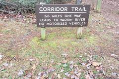
Good sized parking lot with good cell service clean pit toilet and beautiful trail. no parking restriction signs or online. Right on the corner of 2 not very busy roads. was all quiet until Mr Rooster started carrying on, he's a big fella too!! |
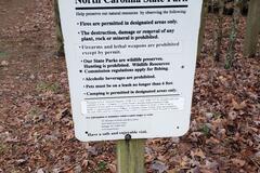
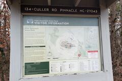
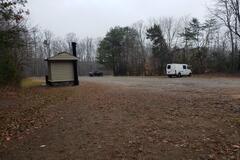
Corridor Trailhead | 36.32756, -80.46292 | |
|
||||
|
Nilson Pritsch
|
This place is in wrong location - it is located at -20.44876, -49.28356 |
Auto Posto Macedão | -20.91666, -49.49734 | |
|
Nilson Pritsch
|
This place is in wrong location - it is located at -20.91666, -49.49734 |
Auto Posto Macedão | -20.91666, -49.49734 | |
|
Nilson Pritsch
|
This place is in wrong location - it is located at -20.44876, -49.28356 |
Auto Posto Macedão | -20.91666, -49.49734 | |
|
chillaxplorers
|
Reachable for 4x4, Sandy road. Not used ground. |
Ground near to the sea | 12.41018, -16.76983 | |
|
||||
|
MonalisanaEstrada
|
Lugar muito bom apesar do forte vento. Chuveiros quentes, solicitar ativação no setor de lubrificação. Wi-fi free. Very good place despite the strong wind. Hot showers, request activation in the lubrication sector. Wifi free. |
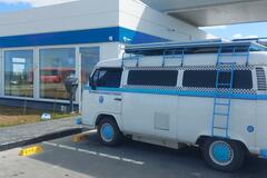
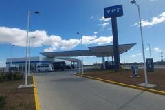
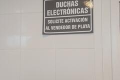
YPF | -53.81008, -67.78044 | |
|
||||
|
suelevivendoosonho
|
ótimo camping pé de areia, toda estrutura necessária, barraca e motor home |
Camping Praia de Itapoa | -26.09421, -48.60377 | |
|
||||
|
samuelablomsdottir
|
good place, i could choose between two menus, there was also fresh bread and salad... including a fresh juice it was 5.500 |
Vegan menu - Govinda restaurant | -30.03423, -70.71198 | |
|
samuelablomsdottir
|
there are a few minimarkets in this village, you get basic things... i think it's the first place, coming from the pass (maybe interesting for cyclists), big supermarket in vicuna |
minimarkets | -29.97737, -70.55508 | |
|
@feralEXPRESS
|
Nice area to spend a few nights. There are no signs prohibiting over night stays. Cell reception is poor on Verizon. |
Yankeetown boat dock. | 29.04162, -82.73648 | |
|
||||
|
mmq-photography.com
|
We've been there very early in the morning, as soon as the park opens at 8am. At that time it's not too crowded. Amazing views of the glacier from several boardwalks. You can do them ALL in 1-2 hours, with plenty of time for pictures and videos. The sign are completely exaggerated... Entrance as of 2023 is 5.500 ARS pp |
Glacier Perito Moreno | -50.46891, -73.02984 | |