Check-Ins
| When? | Who? | Comment | Place | Location |
|---|---|---|---|---|
|
andy.sam
|
Wonderful views. Very quiet day and night. Benches for a picnic with a view. Water tank filled at nearby visitors centre. Great little place. |
Pemberton Community Barn | 50.31680, -122.80000 | |
|
2hobos
|
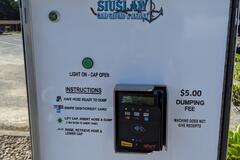
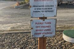
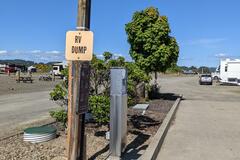
Still here and still $5. Self pay machine. Sign says water is non potable but that there's fresh water available at the boat flush near the parking lot entrance. |
port of siuslaw dump station ($5) | 43.96887, -124.09768 | |
|
||||
|
gcs278
|
Great stay. Was a little worried at first that it would be loud, but got quiet quickly about 11pm. |
Harbor Island Street Parking | 32.72472, -117.19252 | |
|
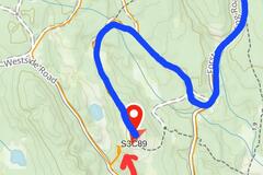
createyourownroadshow.com
|
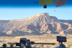
update: rained overnight at this location had to take a different route out due to mud. Follow the blue track in the photos for the easiest way in our out. Still wouldn't risk it if rain is in the forecast. |
Cadejo’s Crest w/ 360 Mountain Views | 50.60661, -116.14700 | |
|
||||
|
jetlagjapan
|
From May 30 it is a campground with a host. It is $23 a night. |
Blackwood Canyon Sno-Park | 39.11412, -120.15841 | |
|
katanarog
|
Great local restaurant selling good simple food at a great price. We had lunch here and came back for dinner. |
Casa Madera | 15.63455, -89.00067 | |
|
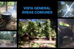
gcarribero
|
área de camping, cabins, todo natural, cabañas en bambú, solo quienes disfruten la naturaleza plena! hablar a Akiana para reservar. +506 60753603 económico y fantástico espacio para amantes de la naturaleza |
Arcturia naturaleza | 10.09541, -83.51111 | |
|
||||
|
lambsundries
|
10 day stay allowed. Some puddles in road. A variety of spots. some trailers here today. I'm in a sunny spot with enough room for a trailer. One bar 5G. |
Lower Lost River Access Free | 43.94037, -113.65012 | |
|
RoadtrekRhonda
|
Just updating the fees. Now $26.25 to $31.50 for camping...all powered sites.
|
Val Marie Campground | 49.24324, -107.73178 | |
|
lambsundries
|
National Forest Trailhead. Picnic table and fire ring. Room for three vehicles at trailhead. The rough road leading to the trailhead is in BLM land. And there are plenty of places to pull off along the road. Follow signs for Cedar Creek, do not follow Google maps after leaving Mackay. Go past land fill, past a sign at a small road pointing further south to the Cedar Creek road entrance sign. Road is rocky, so go slow. There is a dry creek crossing that looks more formidable than it is about half way to the trailhead. |
Cedar Creek Falls Trailhead | 43.96434, -113.58004 | |
|
||||
|
@alyvanblake
|
at this bridge there is a height restriction. we are 2.8m and did not fit. there is no sign but if I had to guess I would say it was maybe 2.6m. there is a nice spot on the town side of this bridge to drive down to the river. |
height restriction | 8.32292, -80.85078 | |
|
Humble Bumble
|
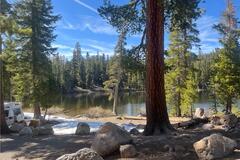
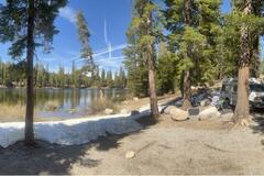
Campground is situated at 7,300 feet. 51 campsites are available. No drinking water. Portable toilets. 14 day stay limit. Each campsite is equiped with a bear locker for food storage. $14 a nite Wow, every site is great. Continue past the first large camp section. First area coming out of Yosemite with usable cell signal. Far off the road with a creek nearby. Just the sound of the wind and water. Only a few rigs mid-week. Yosemite access is reservation only so this is close to the gate to get in before 6 AM or after 4 PM. Yours to enjoy protect and keep clean 🌲 |
Lower Lee Vining USFS Campground (Verizon) | 37.92913, -119.15396 | |
|
||||
|
@alyvanblake
|
this section of road is incredibly steep. our rig barely had enough power to get up this curvy bit. if you are very long, very heavy, or under powered then I would avoid this nasty section. the other way out of town is nice and easy. |
steep hill | 8.59618, -80.15244 | |
|
@alyvanblake
|
we were trying to find out if this road connects, across the river, to the other side via a water crossing. according to our maps is doesn't, but Google Earth like like it's possible. coming from the lake we came across this bridge here. it's super sketchy wood planks on 2 tiny steel beams. we are 4 tons so I got out and walked around it. maybe you would be fine but there is no way I would drive across this. unfortunately I still don't know if you can cross that river crossing up ahead. |
sketchy bridge | 8.47096, -80.83888 | |
|
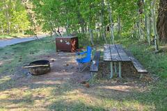
mblaquiere
|
Awesome spot but only 4 of the spots have “sort of level” parking for a van. Wouldn’t bring anything larger than a van in here.
|
Watson Lake Campground | 39.22406, -120.13785 | |
|
||||
|
Merry May Road Trip
|
Nice, wide spot with plenty of room across the road from the river just before the horse corral. Multiple firepits. A little traffic noise from above but we didn’t mind. |
Wild Camping just after Mt Carmelo | 37.20958, -112.68593 | |
|
ma8rty
|
It’s wonderful They appear to let you cut dead fall for firewood so bring a saw and axe |
Seal Rock Campground | 47.70891, -122.89060 | |
|
Mel G Monkelis
|
Great large vehicle turnout overlooking Soap Lake, get 2 bars for internet, quiet. Highway is pretty quiet after 9 pm. |
Vehicle Turnout overlooking Soap Lake | 47.40594, -119.49039 | |
|
||||
|
Gilligan’s RV
|
RV parts and accessories. My Rv cover blew off and they had a new one in stock. |
D R Auto Extras Ltd | 51.21106, -102.43453 | |
|
ampresnal7
|
Great spot just outside of Zion
Wonderful view |
Virgin River | 37.20106, -113.23361 | |
|
||||
|
diamondsontour
|
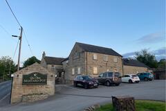
Pub which allows overnight parking in their car park so long as you have a drink or meal. Lisa and Liam will look after you and you’ll enjoy very good food and drink and great friendly staff that give you a warm welcome. Breakfasts are also available in the pub.
|
Ye Olde Mustard Pot | 53.49241, -1.64415 | |
|
||||
|
evers01
|
Place is open and free of charge. Just drive past the Parig Eco Camp and park next to the 54 meter sand dunes. Later in the evening Mr. Razi, who ownes the eco camp came by and explained us about the stars, desert etc and told us we could call him if we needed anything. Also he asked us to leave his number here +98 913 203 0096 so you can inquire up front with him if the wheather is good to stay here. Sometimes to much wind. The eco camp is open as well and you can stay in one of the rooms. |
Hidden in the dunes, no 4WD needed | 32.29960, 52.68429 | |
|
tdupin
|
one of the few filling station on this road. only Cash. |
Engen filling station | -30.19475, 28.14308 | |
|
horstpritz
|
Good Place at the Shore of the River Main. Close to a Ferry.
|
Volkach Stellplatz am Main | 49.87388, 10.16405 | |
|
||||
|
The Pack Track
|
Great place for overlanders, parking right outside your door. We paid 11,000Amd per night, they have a kitchen but you need to ask to use it. |
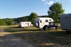
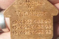
Cottages in Vanadzor | 40.79509, 44.51263 | |
|
||||
|
The Pack Track
|
So easy, as previously stated. We used Covid vaccine certificate, the QR code was scanned to confirm. |
Border Sadakho | 41.22772, 44.83152 | |
|
haroldraben
|
at this moment borders are completely open. from Togo to Benin. Immigration in same building, passport check and i had a evisa for Benin. all took 15 minutes. then cusoms which are 300 mtr in direction of border. i did not need a laissez passer for my motorbike. |
Benin/Togo border | 6.24079, 1.63136 | |
|
nguyenadventures87
|
please explore this place, it is beautiful- quote by a 5 year old. |
Sea Cow Head Lighthouse | 46.31559, -63.80992 | |
|
michael.ingmanson
|
As described. Great spot. Path down is subtle, missed it the first time. Be careful for metal anchors in the cement pad. |
Meat Cove Ridge | 47.02662, -60.53612 | |
|
||||
|
hippysquared.com
|
A beautiful campsite with very good amenities (bathrooms and kitchen). Walking distance to restaurants and beach or alternatively take a kayak to the beach. It was quite but for us appeared like there were lots of parking spots for larger vehicles/motorhomes. Ask where the tap is with filtered water. Cost R$40 ppn |
Padang Surf Camping | -23.39512, -45.00989 | |